 Live Music Archive
 Librivox Free Audio
 Metropolitan Museum
 Cleveland Museum of Art
 Internet Arcade
 Console Living Room
 Books to Borrow
 Open Library
 TV News
 Understanding 9/11
tv Hannity FOX News August 27, 2011 12:00pm-1:00pm PDT
12:00 pm

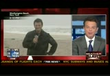
>> shep: we have changes to report. it's 3:00 along the eastern seaboard. changes to show you moments from now from the fox news weather center. i'm shepard smith in new york. special coverage of hurricane irene all day tomorrow and the live look at the color bars, they are beautiful. that was supposed to be a picture of new york city where mayor bloomberg is holding a
12:01 pm
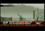
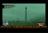
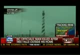
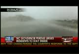
briefing. the city shut down the transit city. most new yorkers don't have cars so bug out saturday here in new york city. that th has never been done because of a national disaster. they are ordering first ever mandatory evacuation for a hurricane. irene came ashore in north carolina. officials blaming two deaths on the storm. they say the first one happened inland, not on the coast, nash county north and east of raleigh a large tree outside the man's home. he died instantly. another man died of heart attack while boarding up windows. word of another death in virginia, a tree crashing into an apartment building in newport news and killing a child in that two-story complex. this associated press report. we don't have it independently. the child reportedly between 9 and 11:00 years old. president obama visiting the headquarters for the emergency
12:02 pm

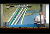
management. they are getting everything they need from the feds. >> they recognize it's going to be tough to get through this thing. they are very appreciative of the opportunity to do all you have done and preparation in place. >> the president says it's going to be a long 72 hours because irene is far from finished. let's get right to the chief meteorologist rick riechmuth with the latest on where the storm is headed. i got a sneak peek at a model. we have some changes. >> reporter: a little less certainty around the new york city area. remember all the models were pointing right over new york, now starting to diverge. as you've been pointing out the jog to the east. it came right there and cape lookout where it made landfall. it was right about here and take
12:03 pm
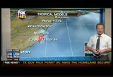
that jog. so it looks like a different path. we'll probably see that correct itself as it continues to pull off to the northeast, tornado concerns you've been reporting causing damage out there already. take a look at the rain making its way right up toward long island. sporadic rain and start seeing constant rain that will continue, but we're still 400 to 500 miles away from the center of the storm. these are the models you were talking about, right here. a little bit of changes and it does make a big difference when you have so much population, a storm in one direction or the other can make a difference. a couple model runs ago, everything was going right over new york city. this model was way over here. it corrected itself and they are spreading out a little bit across parts of long island add in areas of new jersey. that has big implications toward
12:04 pm
new york city. farther to the west, much more water pulling in the hudson river and that is what new york city doesn't want to see, but that is why they ordered all these shutdowns of mt have a and so on. >> shep: i guess you have to ready for a worst case scenario. for mayor bloomberg, a potential real headache. >> reporter: worst case scenario and you have to be prepared if it doesn't happen. people started to say those storms don't happen after you think it's going to happen. they have to do the right thing. we have seen 17 inches of rain in north carolina causing massive flooding. there is a lot of rain to be had up across parts of philadelphia. philadelphia is over 13 inches of rain just this month, and they could get 12-13 inches of rain.
12:05 pm
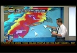
we're talking about in to new jersey. take a look at berkshires and catskills, getting 12 inches of rain. that is going to cause widespread flooding. people think i'm not going to live on the coast, i'm not beginning impacted but that is not the case. >> shep: at one point, long island, they are scheduled to get 3 inches of rain. >> this model is tracking farther to the west. most of the rain is in the center part of it. that is where the bull's-eye is going to be if you are in part of cape islands, they are not going to get it. they will get storm surge same thing with eastern end of long island. but if it tracks to the west which some of the models i like, that is what they are doing, it drys it out. >> shep: the whole country will laugh at it if we get stuck in a hurricane. they will enjoy it immensely.
12:06 pm
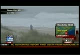
live pictures coming from storm chaser. in north carolina, rick, look at this watch tower. it has not stopped raining as long as we've been watching the pictures. >> it started this morning when they got the bands of rain. winds have been consistent in the outer banks 70-80 mile-an-hour range. >> shep: what is it 74 is minimal hurricane. it wouldn't do a lot of damage if it's moving quickly but this isn't. >> if you have a structure that is taking a beating for a while and takes a beating for a long time, the structures around it the base around it gets beat and it loses it's strength. that is when you start to see more power lines down, more trees down and longer term period of power outages which is what we're going to see. >> shep: it's like the no hit rule with the kids, kid is three
12:07 pm
years old, if he hits you in the same place 30 times, you are in trouble. >> these guys are getting hit over and over again for probably a total of 12 hours. patrolman storm force winds, it's 13 miles an hour. it looks more like 9-10. >> shep: so a later arrival in the northeast. >> i don't want to say it just yet, but delayed by three hours. rain is starting in earnest in about next two hours and it won't stop until it's done. >> shep: only european tourists on the street. >> and new yorkers having fun. >> shep: i hope so. stay inside. thanks. >> and jonathan hunt is speaking of new yorkers, he is in west hampton beach, new york. from these models that dune out
12:08 pm
there west hampton dunes could be in some trouble? >> could be some real trouble. sea is churning pretty ominously behind me. this was the high water tide mark from earlier today. we are already about two feet up this eight-foot dune. the bad news is that around 10:00 tomorrow morning is when high tide is due. the people that live on this narrow strip of land on that side say this is a high tide mark for it to reach anyway. we get high tide at 10:00 a.m. but is right about the height of the storm should hit us here. if you add that high tide anyway with the storm surge from the hurricane or whatever it is, tropical storm moving in, there is a great danger eight-foot dunes will be topped. as frank spins around you can see the properties that are all under a great deal of stress.
12:09 pm
this entire strip of land lined with homes. we've been staying here the dune deck moment, everybody is very concerned, indeed. there is a mandatory evacuation in place here. it's been mandatory since 10:00 a.m. this morning. pretty much everybody has got out so far. we can tell you, shep. there are some peep still here. we talked to one gentleman who says he is not leaving his home. he has 500 sandbags around it. he has wife and kid off of this strip of land and sent them off to safety. but he is staying there to man the pumps himself but most people have heeded the warnings and gotten out of here as they have right along long island. hundreds of thousands of people are being told to get away from the shore. it's called a sunrise highway officials are trying to get everybody inland far enough to ensure their safety.
12:10 pm

it seems for the most part, people are heeding those warnings. >> what about colusi did he heed the warnings? >> he has a house just down the beach, a good friend of yours and he has got out. he took his wife mickey with him. he hasn't board up his property. when we talked to him he basically said, hey, this is mother nature, listen to steve. >> if it's going to go, bet on 19. bet on 19. it could go all the way. you are living on the edge. the ocean is 75 feet from the house. i am living, i chose to live on the edge. >> steve has $250,000 of his excellent art and that may go
12:11 pm
to. he said, maybe the watermarks will make the paintings even more valuable. that is the kind you get out in these beach communities i think. steve as you know is pretty unique character. >> shep: it looks as if somebody brushed his hair? >> that was me, i did a couple shirt buttons up. he likes the buttons up but i tidied him up just for you. >> jonltdz hucht or resident brit standing on the beach. >> shep: i was reporting a little while ago on what we believe or the locals are believed is a tornado. we can't confirm it until the weather service says so. sand bridge area, check that. sand bridge area, i guess five houses have been damaged. a couple of them pretty
12:12 pm
severely. here is the only video we have out of it. the sand bridge area. i thought was another town but we'll check and look it up on. >> danny couch is bucs ton, north carolina, runs tours around the outer bank. it's my understanding you have your own vehicle and take people around. what is your census saying? >> the island i am on is 52 miles long but it averages half-mile wide. we had six breaches in the regular trouble spots here from the ocean today. even though roads were passable you have a lot of salt water. you don't want to drive your car through salt water. as we are getting on the back side, we have 180 degrees from the opposite direction southwesterly and pamicos down is the western inland body of
12:13 pm

water. it's very shallow. when you get a 50 knot wind that water is going somewhere. we have had it down, breached the bulkhead and flooding from the other direction now. >> shep: and new berm on the -- new burn got 17 inches of rain on top of that surge? >> that makes perfect sense. pamicos down on our side is about 45 miles down, it was a bare basin and it's coming up a good seven feet from about 10:30 to 11:00 this morning. hopefully we'll see the newburn area get a drawdown on the water. >> shep: story lines develop out of these things. it sounds like the pamicos sound is going to be one of them. it's almost if you turn a bowl
12:14 pm
of cereal and the milk sloshes all around. it's been bush and pull all day. >> when you have that amount of water and hemmed in and it's shallow nature, there is almost and immediacy of impact in any direction you get. >> shep: danny live on the line. helping us out in con technicals. >> i reported earlier and you know this was in virginia beach. sand bridge area, we said norfolk a little while ago. there is confusion, we have a station that is terrific. they work with us so well and so helpful. they are based in norfolk, this
12:15 pm

is coming from the norfolk station. we don't know of any injuries out of this but we believe this to be a tornado. national weather service will have to confirm that the tornadoes spin out of hurricanes all the time so if you have decided to ride this storm out in an evacuation area that you stay inside. when the winds are fierce, stay away from sliding glass doors and stay in the center of the house, especially if you have kids in there. it's a horrible thing to happen. >> we're waiting for news conference from new york city mayor michael bloomberg. i showed you the developing news spreading out of these models for the storm. it may not be a big deal to on you, but for 20 million or so people that live around here, whether this storm goes just to the left of the city of new york or to the right of the city of new york is going to mean -- i'm guessing here -- hundreds of
12:16 pm

millions of dollars in difference in what is about to happen. if it goes just to the west of us, even these european tourists are going leave times square will be my guess. even they would have to leave. take their american girl bag and whatever they got down at the h&m and head to the house because that storm is coming. hang on! ou're on the road to recovery. proper nutrition can help you get back on your feet. three out of four doctors recommend the ensure brand for extra nutrition. ensure clinical strength has revigor and thirteen grams of protein to protect, preserve, and promote muscle health. and immune balance to help support your immune system. ensure clinical strength... helping you to bounce back. ensure! nutrition in charge!
12:17 pm

okay, so who ordered the cereal that can help lower cholesterol and who ordered the yummy cereal? yummy. that's yours. lower cholesterol. lower cholesterol. i'm yummy. lower cholesterol. i got that wrong didn't i? [ male announcer ] want great taste? honey nut cheerios. want whole gin oats that can helpower cholesterol? honey nut cheerios. it's a win win. good? [ crunching, sipping ] be happy. be healthy. can i try yours? be happy. be healthy. i'm ready. let's do this! i'm so ready. [ female announcer ] when you're prepared for your check-up, you just know you're going to ace it. ready for your check-up? i'm so ready. [ female announcer ] introducing new crest pro-health invigorating clean rinse. its invigorating action lets you know it's working to fight plaque and gingivitis. and provides all these other benefits. new crest pro-health invigorating clean rinse. clean, protect and invigorate your way to better dental check-ups.
12:18 pm

♪ ♪ [ male announcer ] unlike some car companies, nissan is running at 100% which means the most innovative cars, are also the most available cars. nissan, innovation for today. innovation for all.

12:20 pm

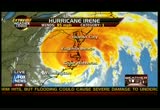
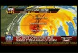
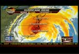
>> shep: 19 minutes past 3:00, as the hurricane continues to churn northward and we believe the hurricane has slowed down but a mile an hour or two miles an hour makes a difference. it changes how long it hits you and how long it hits with the back side winds. this is new voo from nasa is my understanding. this is from the nasa noaagoe project and look at the state of florida and look at the this hurricane, you tell me which is bigger. it's my understanding the rains
12:21 pm
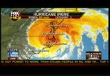
stretched for a thousand miles. hurricane-force winds coming 90 miles from the center. 180 miles across. tropical storm force winds more than double that. no matter where this hits esiond rain are coming. look at that! it's raining from the bottom of the screen to the top of the screen. it's raining in new york and raining in wilmington. this thing is big. doug mckelway, hello? >> reporter: can you hear me talking to you right now. >> shep: i can hear you speaking >> shep: he can't hear me. go doug! he can't hear me, speak to me.
12:22 pm
>> i just lost audio. since you last came to us about an hour ago. let me give you an update. when you last came, winds were 45 miles per hour. i think we're hovering about 50, i'm getting that stinging sand and rain sensation which we did not have before. that is a significant number because at that point, 50 miles an hour, sustained winds the 50 miles an hour, they are calling it quits. they are pulling off the beach. anybody left here is on their own. turning to the waves, as i look behind me here, off the horizon, i can actually see some of the peaks of waves. i've been coming here for long time but as the peaks, some are higher than my head. as they approach the beach they come down, having said that, i just made a 50-yard spread because they are getting closer and closer to the dunes now.
12:23 pm
we are about 20 yards before they reach the dunes. that is key to make sure the dunes hold out and further down the boardwalk and seawall after they built after hurricane gloria when the boardwalk was destroyed. the other thing is rainfall which is foot of rain because it is so low lying. there is a threat to the waste water system, they shut down the waste water system because of the threat of flooding. if you get water over the waste system you have an environmental disaster one thing they would want to avoid. we'll head over to how it's faring. we expect much the same situation as john roberts have been robert go from the sound. we don't know but there is double lined up to keep houses secure. we'll check that out for you.
12:24 pm

>> shep: doug is barely able to hear us. i want to get to pictures that are coming in. these are live pictures, wteg which is fox 5 for the metropolitan area, they are putting sandbags together and residents, it's my understanding they are going to pick up sandbags. is that right? let's listen in here. fox 5, wttg right now. >> they are in a retreat right now. >> right. some of the same people and particularly the manager and then some of the employees themselves. >> reporter: thank you so much for joining us and telling us how this is wrapping up. we can see the end of the line. the lines are dwindling down to almost gone. as he said they are taking this operation, those in lines will get sandbags and they pretty
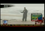
12:25 pm
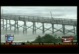
much got their supply here. >> shep: i thank the fox 5 and all of our affiliates. in the fox family. we certainly appreciate it. >> we're keeping a close eye on this. we know this has been watching. we saw it take a jog to the right. national hurricane heachbtd mentioned it. they think it's an anomaly a wobble to the east and probable come back and go along the path. can we be sure? no, sir, we can't be sure. we'll take you back there live. john roberts to devils hills, north carolina, not surprising it's still raining. hello, john. >> reporter: it's still raining and when the hurricane took that jog to the east winds picked up by about 15 miles an hour. so we are in the thick of it now. eye is just a few miles away from us and making its way over the outer banks. the tiv de is coming back in and
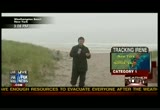
12:26 pm
you can see the ocean, a lot of wind, a lot of waves. and we expect to see the storm surge start to creep it's a way up this dune. we have an update on a couple of things. earlier there was a report that there had been some actual breaches along the outer banks here down to hatteras. but there are were no breaches. unlike isabel in 2003 that cut the island in half where young school students had to take a fer to go to the school this is just overwash. we want to make sure everybody is clear on that. the other story that was out there there had been a breach in a levee at swan quarter which is one of those places where the ferry goes. they built a dike around it after isabel in 2003 but i
12:27 pm
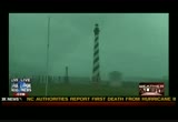
talked to emergency management a short time ago and they have been trying to beat back that story. there has been no breach of the dike there. we expect the winds will continue for probably another four or five hours at this intensity or slightly below as the storm moves it's a way up north toward new york city. it's new york city gets this, i don't want to there. >> shep: i don't want to either. we're on the 12th floor of the fox news building. i have been mentioning storm chasers. i want to go to columbia, north carolina the shot where you saw the light house a little while ago. this is right on the sound, on the south side of the sound. if you were at kill devil hills and you look due west, that is where clum yeah is. tell us what is going roger hill. >> reporter: we're trying to
12:28 pm
aawait the eye and see what relative calmness until the winds turn around the west and crank back to hurricane force. we have been battering waves and there is a lot of downed trees and power lines, right now we are hoping to catch a little break over the next hour as the eye goes overhead. >> shep: during that, it will be calm then and after the eye passes, you get the same thing from a different direction? >> you bet. that is the real strong winds we've had out of east. they will turn out of the west and probably damage things that hadn't been damaged that were shuttleered before from the easterly winds -- sheltered before the easterly winds. >> shep: we want to show you the difference of changes of models now the mayor will react. emergency command from, we
12:29 pm

will be staffed around the clock throughout the storm as we direct the city's response to this emergency. this afternoon's update will focus on evacuation of residents of facilities and other issues. but i did want to first say all the forecasts are basically the same. the storm is headed in this direction, slightly east, slightly west, slighted sli stronger, slightly weaker, but this is a storm where if you are in the wrong place at wrong time it can be fatal. there will be very high winds whether categorized a tropical storm, one, two, three, whatever it is. there is a blot lot of blowing debris. tree limbs come down and water gets into places where it can cause electrical shorts. it is dangerous out there. the thing that makes the most sense for everybody is to first
12:30 pm

comply with the mandatory evacuation. it's done because you may be in danger but as importantly if, god forbid you needed intelligence services, our first responders would have to put their lives in jeff did i to get to you and we are worried we may not be able to get there. you never know when you are going to need a doctor or something like that. the storm continues on track. we don't have any other updates. winds will pick up as you go through the afternoon and then no rain is way a hurricane works. bands of rain that surround it when you between them you think there is no storm. when you under them you get a lot of rain. we're nowhere near the heavy winds. those will come in around 9:00 tonight. the place and time you are likely to have flood damage of
12:31 pm
just literally water of a sudden pouring over the side of the bulkhead is something like 8:00 tomorrow morning. the winds are scheduled to subside late tomorrow afternoon and then we're going to have a whole separate set of issues in how we clean up and mass transit tries to get back which probably isn't going to happen until well into the day on monday. monday morning will be in mess in terms of the commute. our concern is saving lives. our concern is making sure that only thing comes out of this is inconvenience and a little bit of property damage. we don't need people to die. unfortunately i was told about somebody who fell off a ladder earlier when they were trying to board up their house. they haven't died yet but seriously injured. things happen all the time, but we can take some steps and try to minimize the damage and prevent as many as we can. we are also going to talk about power and the possibility of electricity being shut off in
12:32 pm

some areas. kevin is going to help us with that. remember, we're asking buildings to shut off elevators, certainly during that, we don't need people stuck in elevators. if the power goes out while you are in the elevator, we have to get the fire department there and the fire department should be standing by for real emergencies. if you if you haven't evacuated yet, you still have time do it. we have buses at facilities and hail a cop car, some of the taxis are working, or just walk. but just because you say i'm living on the tenth floor and i'm water is not going to get here. that is true but that doesn't mean you could get out if you had to. doesn't mean there will be flying glass and higher you go
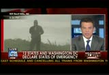
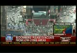
12:33 pm

up the stronger the winds are. we should heed the warnings, please evacuate the areas, low-lying areas and all of the areas. >> as a programming note, when we finish about what is happening here, we will have a presents conference in spanish and take questions from spanish speaking audience. margarita lopez has been out in the field encouraging residents to evacuate will conduct that. let's first talk about nita, if you are a resident in the rock ways, coney island side or any of the low-lying areas you must evacuate now. its mandatory evacuation. your buildings are shutting down. boilers are shutting down. it will be much too dangerous to stay. for the last five hours, we have
12:34 pm

been running bus service to and we home residents that need to have places to stay with family and friends who live in safer areas but in case you don't have friends or friends we do have evacuation centers fully staffed and ready to go. there are about 78 hurricane centers and 8 special medical centers across the city. there is plenty of room. nobody if nyc residents don't want to use free buses to evacuate that we have outside the nyc facilities you could sues a private car. gps data shows the number of taxis on the streets is just below the average for a saturday afternoon. we have moved to zone fare systems, a zone fare system to encourage ride sharing and increase the capacity of each cab. we have directed cabs to go to
12:35 pm

the evacuation areas. deliveries and commuter advance have been authorized to pick up street hails anywhere in the city. if you have to walk, evacuate now. this is all for the zone areas, low-lying areas but the areas that are higher up because if there you would need to have a medical emergency, it's not clear we could get to you. as the winds build up, the bridges may close down. it may not be possible to get off of staten island or get off the rockaways so it's a good time to say okay, better to be safe than sorry. we have been saying this all day. i'm is running out. it's going to get dark and rains will getting heavier and had winds will make it dangerous to be outside. the airports are basically all closed. the staten island ferry is
12:36 pm

running on a one-hour schedule because there is no demand. nobody is showing up at the ferry. we'll continue to do that into later in the day but as soon as the winds start to build, 40 knots at that point we think it's not safe to run them so we will shut those down. the storm is coming. few things that are working, the few places that are open you would expect to close in the very near future. since this morning we have seen a marked increase in the number of people evacuating. most are getting the message but for some reason people have yet to leave. one more time, i hate to sound like a broken record but that is what we're trying to do. if you haven't left you should leave now, not later this evening but leave immediately. let me repeat that in spanish. [ speaking spanish ]
12:37 pm
>> shep: staten island by way of information just celebrated 350th birthday or the settlement. ferry is still running but most live pictures outside our building. we are the corner of 47th street or 48th street at 6th avenue of the americas, rain is coming down but it's not too bad. time squares which is a block to our west. he also talked about the rockaways, a beach in queens, new york. i don't know if i have ever seen no cars on sixth avenue. there are a few. but queens, you may remember 9/11 a plane not related to the attacks fell apart and crashed there, an engine in the backyard. that is a beach in queens. great concern for rockaways and
12:38 pm
other points should this storm come ashore at new york city around the hudson river. those areas would get an enormous storm surge. for this size storm and that means four to ten feet but add that to a potential high tide and add the waves to that. some beautiful beaches that everyday kind of folks could be messed up in a bad way. that would be mighty sad. mother nature is in charge. the mayor says if you have not left, do some leaving except for julie banderas who is in battery park city on the southern tich of manhattan. you can see lady liberty back there. >> julie: i dress today match, you won't be able to see, but the rain has tapered off. we have been getting outer bands of rain. it's interesting how the rains come in.
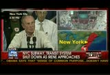
12:39 pm

they start pouring down on us. you would never think a hurricane is on the way. the mayor had a hard lesson when this city was pounded with several feet of snow which shut down the subway system. this time had he has gone ahead and taking the precaution and shut down the system. unprecedented for the big apple. this is very first time the mta has shut down public transportation due to weather. that means no subways, no long island railroad, no transit, nometro north, only way to get around the city is by taxi, foot or car. many new yorkers don't own cars. a loot lot of taxis we're told being summoned to evacuation areas to help those that might be stranded. i am standing in evacuation area. this is zone "a", battery park, mandatory evacuation orders for here, however the making saying they won't be using resources to knock on people's doors.
12:40 pm

this isn't like new orleans or florida where we can do something like that. people are asked to heed the warnings but a lot of people are interested in looking at the live shot. we talked about the bridges. if the winds get up to 60 miles an hour or over, no bridges, that means if you are in the city, out of the city you are not getting in. the airports, no more flights getting into new york area. five airports shut down and all flights cancelled, as for flights you won't be getting into the city until at least monday. airports are open for people to seek shelter. that good thousands. shelters set up around the city prepared for 70,000 people. new york city is all but prepared for this category 1. we're waiting for it. >> shep: thing to think about there, if there is a silver lining to all of this, for many people up and down the coast, if this happened on a weekend, i'm trying to imagine getting wall street operating and midtown
12:41 pm

manhattan and tens of thousands of people that have to come in subway. i don't know how they would do it. the mayor has announced the transit system will be shut down well into monday. well into monday -- that means no longer island railroads, no metro north, no new jersey transit, no subways, no buses well into monday which means nobody has to work monday morning -- except here of course. that is times square. i got word on evacuations and power outages. the latest is 600,000 people, 630,000 homes and businesses have lost power. will it head into new york city? will it just go into the west in new jersey in just to the east on long island? it will matter to millions of people and our weather center is
12:42 pm

getting a good handle out. fox news channel, america's choice for news. premiering the revolution by lg. the newest release with verizon 4g lte. the first phone pre-loaded with access to netflix's massive movie library. powered by verizon 4g lte for an unparalleled streaming experience. see how mobile entertainment was meant to be seen. only with verizon 4g lte.


12:45 pm

♪ ♪ [ male announcer ] with the most advanced engine in its class, 50 horsepower, dual overhead cams and fierce acceleration, the gator xuv 825i will shatter your expectations.
12:46 pm

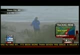
discover the fastest most powerful gator yet, at johndeere.com/gator. >> shep: storm is still going up the eastern seaboard, i would about to say barreling but i believe it's slowed down. it's taking a jog to the north and east. we'll go to the fox extreme weather center. first, let's go to reed temmer and it's my understanding you took a bit of a sand twister. >> yeah, just on the beach here. earlier there was little tornadoes. they are little sand devils are going up and down the shore. >> shep: what are the conditions like aside from the twister? >> the eyewall just came
12:47 pm
through. it just to the east side of the eye and some of the strongest winds i've experienced, pummeled on the bridge 50 feet above the water and you can see the storm surge piling up. it's small debris, it seems to be calming down and a storm surge. >> we've been watching this video you took a short time ago. describe what it's like in the eye? >> we are barely on the east side and strongest part of the east side you add the storm to that, the winds were intense. you could stand up and head were only two for three feet above the ground and it was really intense. we have an armored tank designed to intercept tornadoes and it was bouncing up and down. >> shep: reed with his armored
12:48 pm

tank. reed, thanks a lot. this is visual loop but i think this is visual satellite loop. it's the radar that gives us a better idea. rick riechmuth chief meteorologist in the extreme weather center. >> that one you are looking at is infrared. it's the visual loop or visual satellite. here you go. flood concerns. we've been seeing 10-12 inches across a widespread area. 17 inches and major flash flooding, inland getting flash flooding been causing problems in the coastal areas and getting the surge along that. flooding concerns will be all the way up across the northeast. shep, the radar gives us an idea what the center of the hurricane is doing. we saw it take an eastward jog right there. looks like it's a little bit continuing off to the northeastern jog. instead of being 15 degrees,
12:49 pm
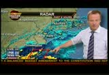
maybe 20 degrees, something like that. that will make a bit of difference as it gets out here over water potentially sooner backs over the main ocean instead of the sound. tornado concerns, the yellow, heaviest of the rain and that is happening across much of the eastern part of the maryland and pushing toward philadelphia and northern half of the southern half of new jersey. now we've seen the first bands moving toward long island and right here, we're starting to see another one and more and more as times goes on. flash flooding in boston because it had some big -- first bands moving through. we've been talking about models, latest runs are coming in kind of separating into two camps but two camps close together here. once again, explain the difference of it. far western areas of long island by the time it makes the land fall tomorrow morning.
12:50 pm
you are thinking east of the city? >> i think it will be just barely east of the city. if not the city. even brooklyn or something like that, j.f.k. could see the center come on shore. that is a real possibility. western long island or the city. >> shep: we'll keep watching you we expected an update from the hurricane center, rick riechmuth fox news chief meteorologist. we're working 18-hour shifts today.
12:51 pm

diabetes testing? what else is new? you get the blood, hope it's enough, it's-- what's this? freestyle lite® blood glucose test strip. sure, i'll try it, but-- [beep] wow. yep, that's the patented freestyle zipwik™ design. it's like it-- [both] targets the blood. yeah, draws it right in. the test starts fast. you need just a third the blood of one touch.® okay. freestyle test strips. i'll take 'em. sure. call or click-- we'll send you strips and a meter, free. can't i just have these? freestyle lite test strips. call or click today.


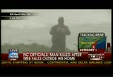
12:54 pm
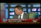
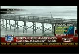
>> shep: seven minutes before the hour, new information on roof collapsing just coming in. this is going to happen throughout the day. a mall in civic center roof this is north carolina. doing a number, a portion of the roof at berkeley mall collapsed sent water and debris down into the stores. let's go to morehead city. jennifer, how is it looking? >> reporter: back half the storm feels a lot stronger than the front half did. every storm is different. that seems to be one of the marks of irene. we're standing on a hill.
12:55 pm
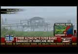
you can't see atlantic beach or see the bridge that has been shut down but you can el how big the waves are. they have knocked out several plarn ks but they have not made it over the seawall. that is good news. a lot of people evacuated, they are hoping most people are not over there on the beach anymore. we have half a million people in north carolina without power. we lost it at 2:00 a.m. and it's still not back. people are surprised. when it came on land, 7:30, half an hour where we were standing. winds sustained at about 85 miles an hour and a lot of rain, but then we had a lull and quieted down and we got hit about 11:00 and second half seems a lot stronger. >> shep: jennifer thank you. >> we're watching this thing as it churns north.
12:56 pm
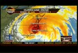
take a look at the loop. we recognize the jog to the right. this is the infrared satellite loop as chief meteorologist rick riechmuth informed us. it has jogged to the east. northeasterly direction over the last, i don't know, 30-45 minutes. that is not to say that will continue. every indication is this storm is going somewhere into new york city. could it be a little to west or east? of course, and it will make enormous difference. on the west side of the storm won't get the storm surge those on the east. say it comes along j.f.k. airport in queens, western end of long island, hamptons would get it. if it comes over new jersey the five burrough's would get it. this storm is real. bill hemmer picks up our
12:57 pm

coverage. i'll see you tonight. also get a free flight. you know that comes with a private island. really? no. it comes with a hat. you see, airline credit cards promise flights for 25,00miles, but... [ man ] there's never any seats for ,000 miles. frustrating, isn't it? but that won't happen with the capital one venture card. you can book any airline anytime. hey, i just said that. after all, isn't traveling hard enough? ow. [ male announcer ] to get the flights you want, sign up for a venture card at capitalone.com. what's in your wallet? uh, it's okay. i've played a pilot before.
12:58 pm

carol. fiber makes me sad. oh common. and how can you talk to me about fiber while you are eating a candy bar? you enjoy that. i am. [ male announcer ] fiber beyond recognition. fiber one. and what it doesn't cover can cost you some money. that's why you should consider an aarp... medicare supplement insurance plan... insured by unitedhealthcare insurance company. all medicare supplement insurance plans can help pay... some of what medicare doesn't, so you could save... thousands of dollars in out-of-pocket expenses. call now for this free information kit and medicare guide. if you're turning 65 or you're already on medicare... you should know about this card -- it's the only one of its kind endorsed by aarp; see if it's right for you. all medicare supplement plans let you keep your own doctor, or hospital that accepts medicare. there are no networks and no referrals needed. help protect yourself from some of what medicare doesn't pay...
12:59 pm

and save up to thousands of dollars in potential... out-of-pocket expenses with an aarp... medicare supplement insurance plan... insured by unitedhealthcare insurance company. call this toll-free number on your screen now... for this free information kit, including this... medicare guide and customized rate quote.
370 Views


Uploaded by TV Archive on
